Scotland: Circumnavigation of the Isle of Arran (2023)
Date: July 2023
Route: Anti clockwise, starting and ending at Seal Shore Campsite
Tidal information: Largely protected by the Kintyre peninsula, Arran sits in the Firth of Clyde, and doesn’t have particularly strong tidal flows. We paddled over neaps, and didn’t really encounter much more than 0.5-1.0kt at times. A tide race forms near the outside of Pladda, but this is easily avoided by passing the island along the inside.
Bear in mind: The southern shoreline is the most exposed, especially in southerly winds, and being very rocky with large groynes extending quite far out from Cleats Shore, round Bennan Head to Kildonan, this is also the most commiting stretch of the circumnavigation.
Getting there: Take the Calmac ferry from Ardrosssan to Brodick which runs frequently throughout the day. Booking in advance is advised during the summer. Yes, you can take your kayak on your car!
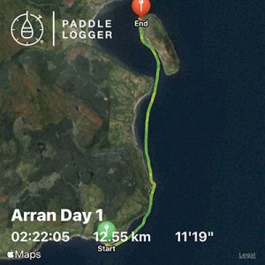 Monday: Seal Shore to Holy Isle
Distance: 12.55km
Weather: 14°C, light rain, wind S/SSW 3bft / gusts 4bft
Arriving on the 14:00 ferry from Ardrossan, my guide Joe and I made our way down to Seal Shore Campsite in Kildonan on the southern tip of Arran, having previously arranged to leave our vehicles there for the days we’d be making our way around the island.
With the forecast for the week showing a steady decline in conditions over the coming days, we were unsure about whether to end the trip on Friday, as originally planned, or to shorten it to four days to arrive back at Seal Shore before the force 5/6 winds that were forecast for the Friday. We decided to wait and see how/if the forecast changed over the next day or so before making a final decision.
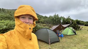
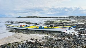
Launching at Seal Shore
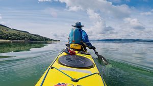
While conditions had been somewhat fair with a stiff breeze during the afternoon, things picked up considerably as we packed our boats – I was paddling my P&H Cetus MV while Joe was in his NDK Romany Excel – and prepared to launch into some decidedly unfriendly 1m swells and gusty southerly winds which pushed us up through Whiting Bay, past Kingscross Point and into Lamlash Bay, where the shape of the land and the bay provided respite from the swell, dishing up calmer albeit rainy conditions as we landed on Holy Isle for the night, and quickly busied ourselves getting a cooking tarp up and our tents pitched on a suitably flat spot, all the while being observed by a large curious seal bobbing about just off the shore. The island is rather dramatic, its highest point Mullach Mòr rising out of Lamlash Bay to a little over 1000ft, with no significant settlements apart from a Buddhist retreat on the western shore.
Camp at Holy Island
With our campsite set up, we hauled our boats up onto the grassy verge well above the high water mark, and as the sun went down, and the lights of Lamlash lit up the bay, we warmed ourselves with hot drinks and a mean pasta puttanesca cooked on Joe’s well-worn Trangia before turning in.
The following morning, after campsite visits by a herd of small deer and a small group of horses, we packed up camp and launched into our second day.
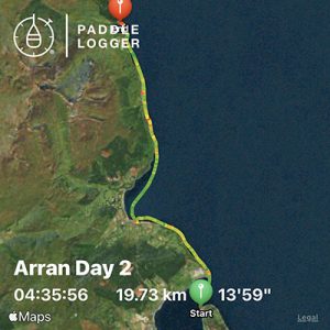 Tuesday: Holy Isle to Sannox North
Distance: 19.73km
Weather: 12°/16°C, light rain, wind NW 1bft / gusts 2bft
Very little wind made Tuesday a calm day of easy, relaxed paddling up to a well known picnic spot just north of Sannox.
We stopped a few times along the way; firstly at the small slipway near the ferry terminal in Brodick for coffee and pastries at the excellent Little Rock Cafe and some groceries at the large Co-Op, secondly for a leg stretch and a quick brew in the small, pretty harbour at Corrie, and finally a quick stop for another stretch on Sannox Beach (there’s a public toilet and shop near to the beach), before arriving at our campsite at Sannox North picnic spot.
Whilst rocky, this section of coast is not hugely committing as there are numerous get-out spots along it should you need them. Landing at Sannox Beach itself is particularly easy as it’s very sandy.
North Sannox Burn at Sannox picnic spot
As we arrived at Sannox North at low water, we couldn’t paddle very close to the camping area, so we waist-towed our boats as far up the North Sannox Burn river as possible, before pulling them out onto the rocky shore, unloading them, and then carrying them, once they were empty, up to a spot just in front of the grassy picnic area. The river has fresh, crisp mountain water, and if you follow it up a short distance from the picnic area, there’s a small pool where you can take a cheeky dip! The fresh water also proved useful for rinsing out neoprene gear (we all know how rank that stuff gets after a day or two!).
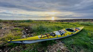
“Cetus Sunrise”
Since this is a picnic spot, there were a few others at this campsite, making it somewhat more challenging to find a private toilet spot, but there’s a narrow path you can take up the hill to the west to take care of business. There are a few smaller, more private spots a little further north up the coast that could be used for overnight camping, should the picnic area not appeal.
The weather over the course of the afternoon was occasionally wet but turned into a lovely warm evening. We whipped up a mushroom risotto on the Trangia and I enjoyed some cider as dusk approached.
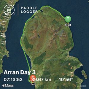 Wednesday: Sannox North to Blackwaterfoot
Distance: 39.67km
Weather: 14°/19°C, occasional light rain, wind NW 2bft / gusts 3bft rising to WNW 3bft / gusts 3bft
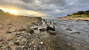
Rising at 4am on Wednesday morning for a 6am launch, the beautiful sunrise was really quite something! Launching at high water meant we could push our boats in just a stone’s throw from where we’d put them overnight, directly into the burn and out into the bay.
It was, however, clear that Friday’s dire forecast wasn’t going to change, so we made the decision to make a big push down to the small town of Blackwaterfoot, to cover maximum ground before what would now be our last leg on Thursday.
Sunrise at Sannox
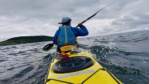
The forecast for Wedneday had been quite gusty, but apart from a slightly blustery morning paddling against a little bit of tide, much of the late morning into the afternoon was incredibly calm, with easy paddling through smooth glassy seas. We saw plenty of curious seals, one or two sea otters and a multitude of different species of jellyfish around us, including numerous barrel and lion’s mane jellies, and some large crabs scuttling about along the sea bed. It was pretty glorious. I also couldn’t resist wending my way through a few rock gardens around the Cock of Arran (teehee).
Best. Sandwiches. Ever.
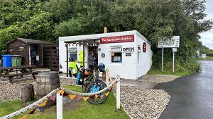
Best of all, we stopped at the small pebbly beach next to the ferry terminal in Lochranza for sandwiches at the unassumingly named The Sandwich Station nearby. Best sandwiches in the known universe? Quite possibly. Great coffee too. The ferry terminal also has excellent toilet facilities.
Heading southwest through Catacol Bay, past Thundergay (heh) and Pirnmill, where we had a quick stretch, we finally rounded Imachar Point (which, incidentally, would have been our campsite if we’d not been pressing onwards) to face southeast, when the weather started to change somewhat, and we could see rainclouds coming in from the west.
Paddling around Pirnmill
As we made the 6km crossing across Machrie Bay, the calm conditions we’d enjoyed all morning took quite a turn, the wind whipping up a fair amount of chop across our beams which made getting across to the Kings Caves and around Drumadoon Point rather hard work! As always, my stern-mounted GoPro somehow flattened out the footage, making our lumpy ride look far more tame than it was; as the Cetus sits quite low in the water, I was hit more than once with kidney-freezing waves crashing over the back deck. Ooomph!
Enjoying a bit of chop in Machrie Bay
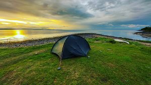
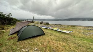
By the time we arrived in Blackwaterfoot and made landing on the beach, I was sorely in need of a leg stretch, a snack and a pint courtesy of the hotel bar near the small harbour. Unfortunately the level of the Black Water river was too low for us to paddle up it so we had to haul the boats up the beach, unpack and cover them with a tarp to protect them from the incoming rain, before leaving them along a rocky wall for the night, while we camped nearby on a grassy verge overlooking the shoreline.
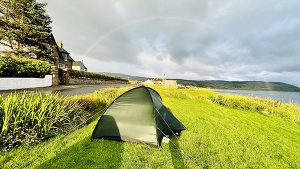
Camping on the outskirts of Blackwaterfoot
The town has a small shop, the aforementioned bar and hotel, a bakery and an excellent public toilet maintained by a local community group (if you go, please be sure to take some change to donate in their donations box!), which makes it a useful stop, especially after a couple of days! Joe cooked a tasty bean chilli with wraps, and we ate as we flopped in our camp chairs looking out at the sunset.
Despite camping alongside a road, it was a very peaceful night with the sound of the waves lapping on the rocks below.
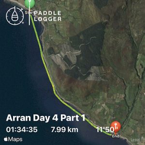 Thursday: Blackwaterfoot to Sliddery
Distance: 7.99km
Weather: 11°C, occasional light rain, wind SW/SE 4bft / gusts 5bft
As we checked forecasts and made our plan for the day, it was clear that we’d have to make a stop roughly around the halfway mark of our day’s route, to avoid a period of high southerly winds, problematic because we were paddling along the south coast, and also because of the amount of fetch to the south of the island. The southern coastline has some treacherous rocky shelves that we were keen to avoid running into trouble around.
We launched out into a rather choppy but manageable Drumadoon Bay, hoping to get to Cleats Shore before the conditions worsened, but unfortunately the weather doesn’t always play ball with punctuality, and things started getting quite nasty when we were still around 30 minutes from our intended destination.
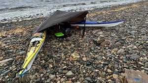
Shelter on Sliddery
Faced with a choice of battling the wind and waves to Cleats, or getting out with more urgency, we made the decision to immediately turn towards Sliddery beach, a decidedly unfriendly and barren shoreline with some sharp rock shelves just offshore, where we made a slightly tricky landing in dumping surf beneath ominously darkened skies, before hastily organising a shelter against the pelting rain with our boats and a tarp. With the wind and rain making things very chilly indeed, I got out of my paddling gear and into warm clothes, and we gathered up a load of salt-dried wood and got a small fire going, making some coffee and hot porridge before settling in for what turned out to be a six hour wait for conditions to improve.
We passed the time whittling kindling off sticks, feeding the fire, making coffee and just generally keeping chipper. Methinks a deck of cards will come in handy for future expeditions!
By the late afternoon, the winds had dropped a fair amount, and while there was some residual sea state, we figured it was good enough to launch back out, especially as the forecast showed conditions would continue to improve over the coming hours. We packed everything away, cleaned up our shelter area, carried our boats past the now-exposed rock shelves, and launched.
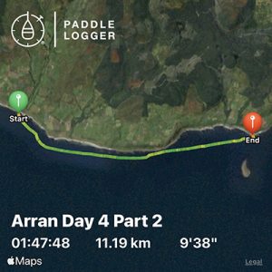 Thursday: Sliddery to Seal Shore
Distance: 11.19km
Weather: 16°C, occasionally sunny, wind SW 2bft / gusts 3bft
As we paddled out into some residual lumps and bumps, keeping an eye out for large rocks around the bay along Cleats shore (even though we were keeping our distance from shore, we encountered several large ones lurking out in the bay), we finally caught sight of Pladda, the small island just south of Seal Shore. Our finish line!
It was a fun, choppy last leg in quite pleasant conditions, paddling round Bennan Head, whilst maintaining a fair distance from shore to avoid the long, sharp groynes which extend into the bay for much of this stretch.
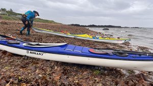
Back at Seal Shore
With more quarterly winds giving us a slight nudge from behind, we made really good time on this leg, landing in very seaweedy low water at Seal Point. After hauling our boats out, setting up camp, wolfing down a campfire lentil dahl, we popped into the nearby Kildonan Hotel bar for a well-earned pint and ice cream, we celebrated a brilliant circumnavigation while watching two sea otters frolicking about on the rocks on the beach. As luck would have it, the sea was now, once again, a glassy smooth mirror of serenity. Bah!
Arran is a stunning island with so much to see, and its featured coastline provides a full range of paddling opportunities. On the Friday we drove our kayaks back up to Lochranza for some paddling (and, admittedly, more sandwiches from The Sandwich Station), the bay there largely unaffected by the high southerly winds that were now battering the southern shores; the beauty of islands, especially ones surrounded by land, is that you can almost always find suitable spots to paddle, regardless of the weather.
 As with any circumnavigation, good planning and regular checking of forecasts are essential throughout the trip, and for this particular trip, I’d recommend paddlers have, at the very least, their British Canoeing Sea Kayak Award, or equivalent training. If you’ve done your Coastal Sea Kayak Award, even better, as conditions can change, and Neptune likes to throw the odd curveball to keep us on our toes.
My guide for this trip was Joe from Rogan Coaching. It was my second expedition with Joe, and he’s a fantastic guide and coach, a veritable encyclopedia of bushcraft and paddling knowledge, and just good craic!
Gear list for those who like the small details
Kayak: P&H Cetus MV custom
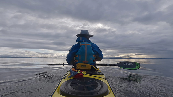
Paddle: Celtic Omega 650 (Spare: Aqua-Bound Sting Ray Hybrid)
GPS: Garmin GPSMAP 66sr
Tent: Hilleberg Niak
Sleep system: Mountain Equipment Helium quilt, Thermarest NeoAir XLite NXT Regular mat, Big Agnes Boundary Camp pillow, Sea to Summit Reactor Thermolite liner
Power: Goal Zero Sherpa 100AC, Goal Zero Venture 75
Paddling and rain gear: Kokatat Tempest cag, Palm NeoFlex leggings, Palm Helios baselayer shirt, NRS Kicker shoes, Outdoor Research Seattle Rain Hat, Fjallraven Hydratic Vardag anorak, Berghaus Paclite Gore-Tex overtrousers


